Detailed geophysical and geological investigations to identify copper lead and zinc mineralization around Ambaji, Banaskantha district are in progress.

 Skip To Main Content
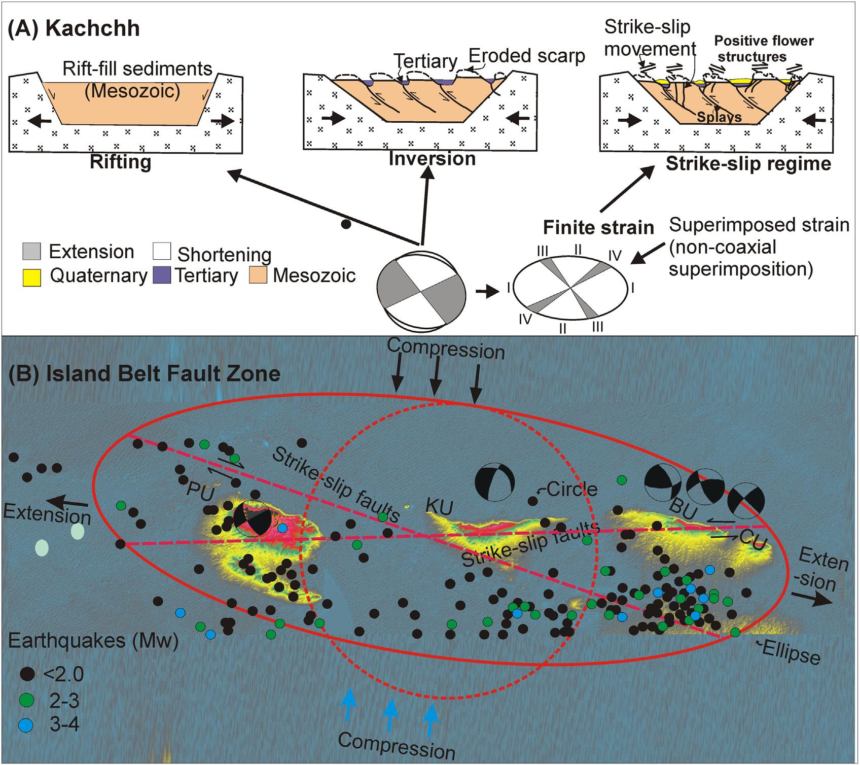
The Island Belt Fault Zone (IBZ) and Wagad-upland that are associated with past and recent earthquakes, have been investigated to ascertain the role of tectonics in landform evolution. Towards this, we used data from fill and strath terraces employing conventional geomorphology, sedimentology and optical chronology. The study suggests episodic accelerated crustal deformation along the NE-SW and NW-SE trending transverse strike-slip faults that are genetically related to the regional N-S directed compression. The deformation events are optically dated to ~61 ka, 47 ka, 38 ka, 29 ka, 15 ka and 2 ka. Uplift rate has been estimated from the height and age of the strath terraces along the river valleys of IBZ and Wagad upland. The study observed a significantly lower uplift rate (0.2–0.06mm/year) compared to the Kachchh mainland (~1 mm). This is ascribed to the strain partitioning caused due to the presence of the KMF and KHF located in the south of the IBZ. Further, it is hypothesized that the restraining and releasing bends along the strike-slip faults could act as barriers to earthquake propagation and might act as nucleation sites for major earthquakes in the intraplate setting. Thus, the study calls for the identification of such locations in order to assess the severity of the future earthquakes in the region.

(A) Conceptual model (schematic) showing the evolution of the Kachchh Peninsula, (B) A tentative model suggesting the evolution of the Island Belt-Fault Zone (IBZ)
Bhattacharya F., Chauhan G., Durga Prasad A., Patel R.C. and Thakkar M.G. (2019) Strike-slip faults in an intraplate setting and their significance for landform evolution in the Kachchh peninsula, Western India, Geomorphology 328, 118–137.
Copyright © 2017 - All Rights Reserved by - Official Website of Institute of Seismological Research, Government Of Gujarat, India.
Note: Content on this website is published and managed by Institute of Seismological Research.
For any query regarding this website, please contact the web information manager Mr. Jignesh Patel (Technical Officer) : email id-dg-isr[at]gujarat[dot]gov[dot]in
