Detailed geophysical and geological investigations to identify copper lead and zinc mineralization around Ambaji, Banaskantha district are in progress.

 Skip To Main Content
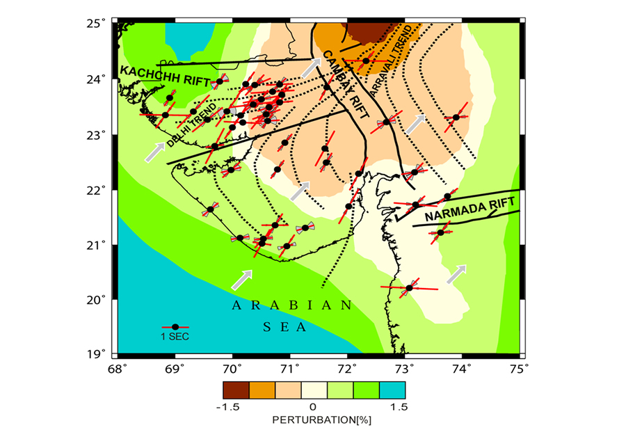
The northwestern Deccan Volcanic Province in India has witnessed several tectonic episodes resulting in the formation of rift zones, wide spread magmatism, and deep-seated faults that are host to some deadly intraplate earthquakes. In this study, we attempt to decipher the mantle deformation beneath the region using the SKS splitting technique applied to high-quality data from a regional network comprising 44 broadband seismic stations sited on diverse tectonic environments. The first measurements of 461 (312 SKS and 149 SKKS) splitting parameters from 117 earthquake sources reveal two major trends, one coinciding with the absolute plate motion (APM) of the Indian plate and the other roughly oriented in the E-W direction. Forward modeling of the dependence of the splitting parameters on incoming polarization assuming horizontal axis of symmetry brings out two layers of anisotropy beneath the study region with the fast axis azimuths oriented N22°E in the bottom layer and N77°E in the top layer. While stronger anisotropy (δt∼1.2 s) in the bottom layer is related to asthenospheric flow, a weaker anisotropy (δt∼ 0.5 s) in the upper layer could represent anisotropy frozen in the lithosphere due to deformation related to widespread magmatism in this plume affected region.

Fast polarization directions and delay times on tomography image (Kennets anomaly).The APM directions are shown as arrows
Rao, K.M., Kumar, M.R., Singh , A. and Rastogi, B.K., 2013, Two distinct shear wave splitting directions in the northwestern Deccan Volcanic Province, Journal of Geophysical Research, Solid Earth, v.118, p.1-13.
Copyright © 2017 - All Rights Reserved by - Official Website of Institute of Seismological Research, Government Of Gujarat, India.
Note: Content on this website is published and managed by Institute of Seismological Research.
For any query regarding this website, please contact the web information manager Mr. Jignesh Patel (Technical Officer) : email id-dg-isr[at]gujarat[dot]gov[dot]in
