Detailed geophysical and geological investigations to identify copper lead and zinc mineralization around Ambaji, Banaskantha district are in progress.

 Skip To Main Content
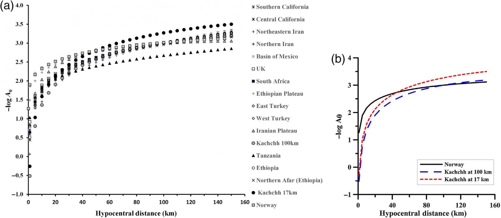
A calibrated local magnitude scale (ML) is essential for seismic hazard assessment of seismically active regions. In this study, an ML has been developed for the Kachchh region for the first time. This scale is derived using 9167 amplitude measurements on the horizontal-component recordings of 1456 earthquakes, with hypocentral distances ranging from 6 to 100 km. All the amplitude measurements were inverted simultaneously to determine constants of the ML and station corrections for the Kachchh region. The resulting distance correction term is given by -log(A0)=1.86log(r/17)-0.00195(r-17)+2 and -log(A0)=1.83log(r/100)-0.00236(r-100)+3 for 17 and 100 km normalizations, respectively. The distance correction term at 17 km normalization suggests that attenuation in the Kachchh region is higher than in other regions of the world, for hypocentral distances above 45 km. Also, the standard deviation of the magnitude residuals was computed to check the effect of the new attenuation terms on the magnitude estimates. Although the standard deviation without station correction is 0.26 (variance σ2=0.068), the value is 0.22 (variance σ2=0.048) with station correction. This indicates that station correction reduces the variance by 30% and brings the average residual closer to zero. The station corrections obtained in the present study varied from -0.20 to +0.27. The relationship between the local magnitude ML (this study) and the moment magnitude Mw reveals that the derived Mw is larger for earthquakes with magnitudes smaller than 3 and smaller for earthquakes of larger magnitudes.

(a) Comparison of the attenuation curves from various studies and (b) comparison of attenuation curves presently used and those obtained in the present study using 17 and 100 km normalizations.
Joshi V., Chopra, S., and Kumar S. (2018) A Local Magnitude Scale (ML) for the Kachchh Rift Basin: An Active Intraplate Region, Gujarat, India, Bulletin of the Seismological Society of America, doi: 10.1785/0120180138.
Copyright © 2017 - All Rights Reserved by - Official Website of Institute of Seismological Research, Government Of Gujarat, India.
Note: Content on this website is published and managed by Institute of Seismological Research.
For any query regarding this website, please contact the web information manager Mr. Jignesh Patel (Technical Officer) : email id-dg-isr[at]gujarat[dot]gov[dot]in
